
We have been in Norway for two weeks now and it is time to take you with us.
Norway has one of the most fascinating landscapes we have seen on our trip so far.
Our arrival
We arrived by ferry from Denmark, the distance Hirtshals-Kristiansand did not even take three hours. Everything went absolutely unproblematic: checking in on the ferry, fastening the motorcycles (sufficient lashing straps available on board), the time on deck with the unusual view of the sea and last but not least the entry: we were simply waved through. And then we were there. In Norway. That we had waited and hoped for during our corona-related break. And wow, the landscape pulled out all the stops right away.
Lindesnes. Only 2518 kilometers to the North Cape
We had chosen a camping site near Lindesnes for the first night. The lighthouse there is also called the South Cape of Norway, so we want to drive the route from the South Cape to the North Cape. We avoid the big E39 and let Calimoto, our navigation app, find a nice little road. And already the small road lets us fly around the curves with open mouth: the Norwegian landscape is stunning: full of lakes, small rivers, red cottages, rocky islets, only covered with a few birches. We feel like we are in an Astrid Lindgren landscape, knowing that she comes from Sweden and not from Norway.
When we arrive at the campsite we float on cloud nine, only to be pushed into a wet and muddy corner: the site is optimized for motor homes and tents are neglected exotics. We briefly consider whether to continue, but the lighthouse is too much of an attraction for us, and after dinner we are already relaxed again and head for the southern tip of the peninsula.
We arrive at the Lindesnes parking lot around half past eight, the ticket counter is already closed (which saves us about 10 Euro per person), but the way to the lighthouse is free. And the place is stunning. The lighthouse is the oldest and southernmost tower on the Norwegian mainland. It was first built in 1656 and last renovated in 1915. What particularly impresses us is the view: from the rock on which the tower was built, you have a wide view over the sea, and it is no wonder that a dozen other people enjoy the sunset beside us.
And we only have 2518 kilometers left to the North Cape.

Lysefjord. Absolutely fascinating nature experience
The next morning we leave our muddy place and drive towards Lysefjord. Yesterday we thought it couldn’t get any nicer, but today we are taught a better lesson: The plateau in front of the Lysefjord is one of the most beautiful roads we have seen so far. But it is not easy to describe it without it becoming kitschy: after several weeks of rain it is wet and a bit foggy. Many small lakes in a grey rocky landscape. Soft afternoon light. A lot of moss. Green and yellow lichens. And everything seems slightly mystical, I wouldn’t have been surprised if a unicorn had trotted across the road. We are blown away.
And we still have luck. Normally, Norway is firmly in the hands of tourists during the summer months. On the Internet you can find descriptions like “camper to camper”, overcrowded tent sites, campervans at the roadside everywhere, etc. But not this year. As bad as Corona is for those affected and everyone else, Norway is pleasantly empty in 2020. We had considered wildcamping, but the view from the top of the campsite at Lysefjord shows us a bright green and almost empty place. So we only drive the 27 hairpin bends down that day and not up again. Phew. Twenty-seven narrow hairpin bends with the motorcycle are quite a job. And the path is so steep that it ends in a tunnel 1100 meters long at the end, because otherwise the sweeping technique can’t cope with the height. The nice place below with a view of the fjord and good WLAN makes us forget the effort of the day quickly.
Speaking of effort: we have found that daily stages of 200 to 250 kilometers are good for us. We don’t have to set an alarm clock in the morning, can relax and wait until the tent is halfway dry, and then set off. Depending on the route, we have a look at something on the way, have a lunch break somewhere along the road and don’t arrive at our destination too exhausted in the evening. This way travelling is fun.

Hike to Preikestolen
The next day we drive back along the beautiful road, make a big curve to the south and end up on the same fjord as the day before, only on the north side – we want to climb the famous Preikestolen. The Norwegian website says: “Walking to the pulpit is of moderate difficulty. The round trip of 8 kilometers takes about 4-5 hours. The path leads through different landscapes, such as forest, moor and over stone stairs, which were built by sherpas from Nepal”.
Apparently we were so enthusiastic about the information about the Sherpas that we did not read the most important sentence: “Most visitors find the hike strenuous. And it was really exhausting. It was hot. It was steep. And the steps made of coarse stones were so high that it was often more climbing than stair climbing for me. pBut once I reached the top, the effort was quickly forgotten. The Prediger Rock is really worth it. The view to the Lysefjord is beautiful and it is not as crowded as I feared. Overall we enjoyed the day very much and can only recommend this hike. Also the sore muscles the next day are surprisingly limited.

Brygge: Tolles Hafenviertel in Bergen
After an overnight stay on a camping site at the Hardangerfjord we are finally in a bigger city again: we have two days off in Bergen. We stroll through the alleys, visit the port and the adjacent Brygge: the Hanseatic quarter where merchants used to live. The old wooden houses inspire us, the port less so. Too much show. On most yachts people sit with cocktails in their hands on the presentation plate. We have discovered the place of high society and find it rather repulsive.
Then take the Floybanen up to the peaks above Bergen: the train takes only a few minutes and offers a beautiful view of Bergen from above. We hike through the forest, find many wooden statues of trolls and even the Tubakuba, which we had read about before but then forgot: The Tubakuba is a small hut built by architecture students with an opening like a tuba. It can be rented free of charge by families with children for one night each, in order to introduce the children to nature. Beautiful idea – beautiful realization.
The beautiful Sognefjord
By far the most beautiful fjord so far is the Sognefjord, which we reach after a day’s journey from Bergen. This is the longest and deepest fjord in Europe. Because of the glacier’s melt water the water shimmers turquoise and slightly milky. We can’t get enough of each other. We drive almost the whole day along some side arms of the fjord, in the evening we have a camping site with a perfect view of the fjord. The warm and sunny weather tempts us to put on bikini or swimming trunks and jump into the water before dinner. Heavens, it’s cold. The lake must have defrosted yesterday. But after a few swims the water feels much warmer and we enjoy the crystal clear water.
Later in the evening we light our gas stove, there is rainbow trout with vegetables, caught by hand from the freezer of the local supermarket. We end the evening on our comfortable Helinox chairs, with a glass of wine in our hands and the brilliant view over the fjord.
Mücken: ein eher unangenehmes Thema
A little bit more about mosquitoes: Norway is considered to be rich in mosquitoes, every travel guide recommends to have a repellent with you. We have of course also, but we use it more rarely than feared. We are there in August, so at the main mosquito time, but we often manage to have a little wind around the tent, so that the mosquito plague is kept within limits. But a little wind can’t completely prevent the plague. If they start to get on our nerves, we retreat into the tent.
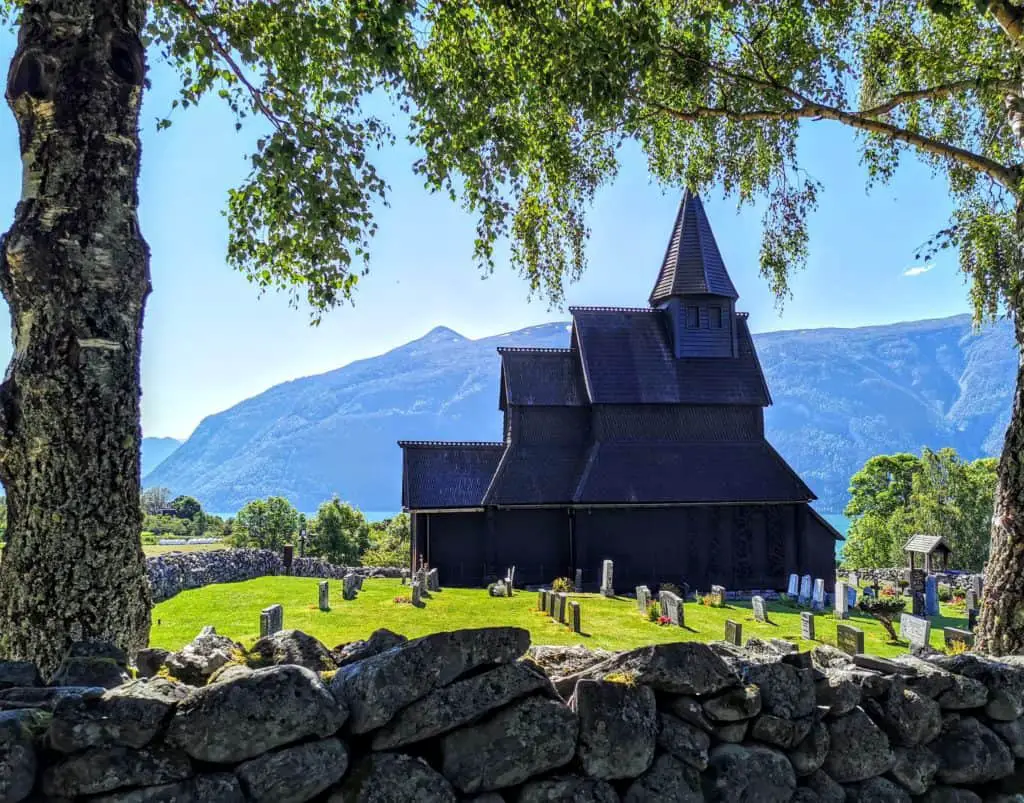
The stave church of Urnes
The next morning we leave the Sognefjord heading north. Our morning destination is the stave church in Urnes.
To get there we leave the 55 and turn on a narrow, beautifully curved serpentine road towards the water until we reach the ferry pier. When we arrive, the barrier to the ferry is already closed and we curse a little, because there is only one ferry here.
But the boatman sees us, raises the barrier again and lets us on board. Unfortunately, this process takes a little time, because we have to board backwards. Wolfgang turns already in front of the bridge and “runs” his bike then backwards, I decide to take the short ascent and have to turn with several trains on the bridge. Of course everyone is watching and I take special care not to look too stressed. Backwards I let the Honda roll to the right place, perfectly instructed by the skipper, who stands in front of me and directs by hand signal to the right and left until I stand correctly. Phew. But we enjoy the great crossing all the more.
The trip by ship takes just under a quarter of an hour. The stave church itself can be reached after a fifteen minute walk up the mountain, which we elegantly master with the motorcycles. The church from the outside as well as the cemetery can also be seen without a ticket, but we pay the approximately 10 Euro per person and take part in the guided tour. The church itself is impressive. Originally built in 1100, it is considered the oldest stave church in the world. The building that is still preserved today dates from the 12th and 13th century. The name stave church comes from its construction: a supporting structure of vertical trunks, the so-called bars, on which the entire roof construction rests. We hear that the church is repainted with tar every five years to withstand the Norwegian climate.
For the rest of the trip we stay on the fjord side, where the church is located. Motorhomes are not advised to take this road, which is actually very small and narrow. As so often in Norway, it reminds us of the Scottish “single trails“: narrow roads, just sufficient for one vehicle width, and every 50 to 100 meters an alternative bay. In combination with the slow driving style of the Norwegians, this principle works very well.
Geirangerfjord and Trollstigen
A little later we reach the two highlights that almost every traveller to Norway sees: Lotefossen, Geirangerfjord and Trollstigen.
If you travel from the south, the Geirangerfjord is the first fjord that looks really wild: a deep gorge between steep rocks, which is visible from far away and accordingly impressive. This is exactly how we imagined the fjords of Norway. And Trollstigen is a mountain road that winds its way past high waterfalls and lots of sheep along the way down into the valley and is just fun to ride on a motorcycle. The Norwegians have provided these beauties with good infrastructure: Viewing platforms at exactly the right places channel the traffic, but also offer great photo motives as well as sanitary facilities and restaurants.

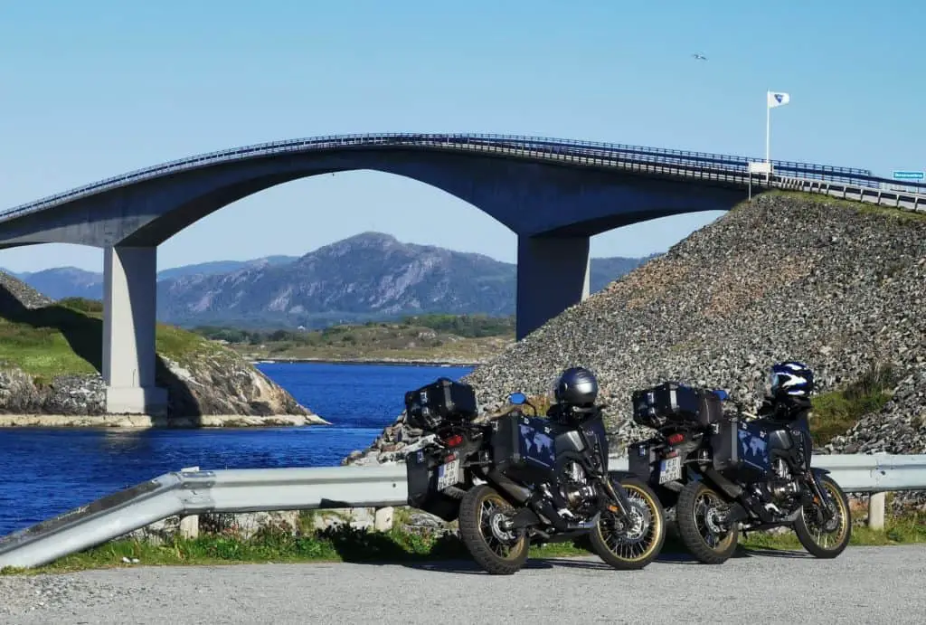
Rightly highly praised: the Atlantic Road
We reach another highlight of southern Norway the following day: the Atlantic Road. This is an eight-kilometer-long coastal road that runs across several small islands and over eight bridges. The pictures on the Internet that are taken with a drone look particularly spectacular, but just driving along the road gives me an adrenaline rush. The bridges are quite high, a bit steep and especially at the Storseisund Bridge I have the feeling of driving up a launch pad. Of course the road looks normal again at the top, but it’s still fun.
We like the road so much that the next morning we drive back the 20 kilometers from our campsite to the bridge to enjoy the experience once again. It is a bit like flying. Norway is simply wonderful.
So much for today. Our time in Norway is too long to fit into a single article. Part two and three will follow. Be curious how we fared in Trondheim and if we still managed to see moose in the end…
Desire to see more pictures. Then go to our picture gallery Norway!
And if you are interested in the follow-up reports on Norway: here are all four links:
- Norway Part 1: The south of Norway – fascinating landscapes
- Norway Part 2: Auf dem Weg zum Nordkap
- Norway Part 3: Stürmisches Wetter auf den Lofoten
- Norway Part 4: Wir sind am Nordkap – und finden es spektakulär